
Destination Guide · Samaná · Winter Base (Dec–Apr)
Los Haitises National Park
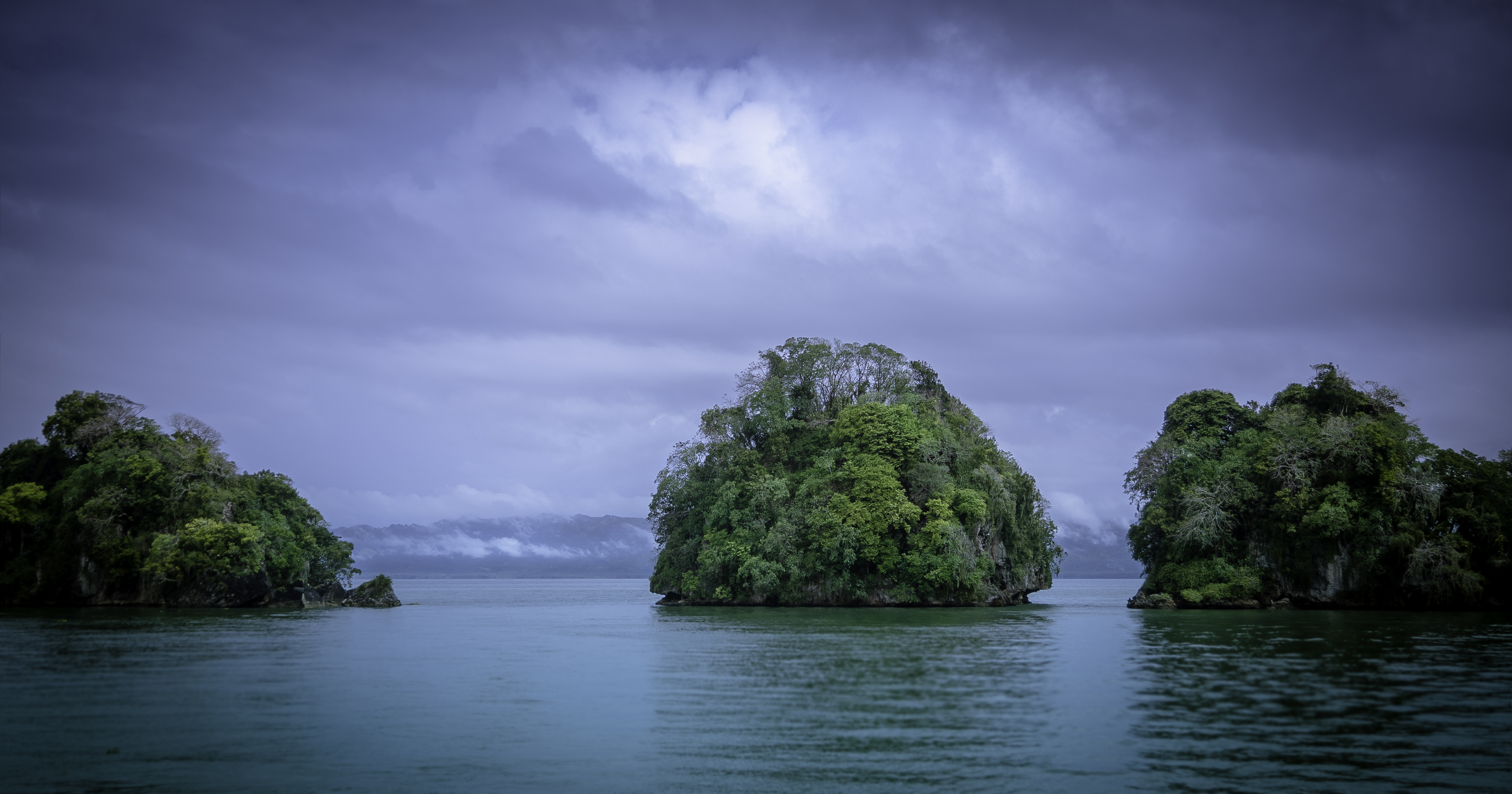
Karst mogotes, mangrove channels, and pre-Columbian Taíno caves — the flagship day of the winter chapter, twelve miles across the bay.
From Marina Puerto Bahía
12 nautical miles · 2-3 hour reach across Samaná Bay
Best time to sail
December to April, during the winter base season. Mornings are calmest for the mangrove channels and the caves; the park is at its quietest before the day-trippers from Sabana de la Mar arrive by road.
Los Haitises National Park is the flagship day of the winter season — about twelve nautical miles across Samaná Bay from Marina Puerto Bahía, on the southern shore. It is a karst limestone plateau that breaks straight into the sea: conical hills called mogotes covered in dense tropical forest, sinkholes, mangrove channels, and a coast of sea caves that hold pre-Columbian Taíno petroglyphs and pictographs. There is nothing else like it in the Caribbean.
We sail across the green bay in the morning and pick up the gateway anchorage at Bahía de San Lorenzo, at the foot of the mogotes. From there guests transfer to the tender to thread the mangrove channels — the greatest abundance of Caribbean mangrove anywhere — and to step ashore at Cueva de la Línea and Cueva del Ferrocarril, where the Taíno carved hawks, faces, and whales into the cave walls long before European arrival. Over two hundred bird species live in the park: the brown pelican and the magnificent frigatebird wheel overhead, the Hispaniolan parrot calls from the canopy, and the critically rare Ridgway's hawk — fewer than five hundred left — hunts the mogotes.
It is the kind of day that makes the bay feel oceanic. Karst, mangrove, sea cave, forest, and bird life folded into the same eight or nine hours, with the yacht anchored at the foot of the mogotes and the tender threading water that opens out into hidden lagoons. We are back across the bay to the marina by evening, the humpbacks often visible somewhere astern.
Anchorages
Bahía de San Lorenzo
The gateway anchorage into the park, on the southern shore of Samaná Bay at the foot of the karst — flat water under the mogotes, the obvious place to lie at anchor while the tender threads the mangroves and caves.
Mangrove channels
The labyrinth of mangrove waterways behind San Lorenzo — tendered, not sailed. Hidden lagoons open out at every turn, herons and pelicans in the roots, and the park's birdlife thickest in the calm of the morning.
Cave coast
The limestone sea-cave coast inside the park — Cueva de la Línea, Cueva del Ferrocarril, and Cueva de la Arena — reached by tender from the anchorage, with Taíno petroglyphs and pictographs on the cave walls.
Ashore
Taíno cave petroglyphs
Hawks, faces, whales, and ceremonial figures carved into the cave walls by the Taíno long before European arrival — the most important pre-Columbian rock art in the Dominican Republic, reached on foot from the tender at San Lorenzo.
Birdlife
Over two hundred species — the magnificent frigatebird and brown pelican overhead, the Hispaniolan parrot in the canopy, and the critically rare Ridgway's hawk hunting the mogotes. A national park guide joins the day to call them.
Mogotes & mangrove
The karst hills jutting straight out of the sea, draped in tropical forest, and the greatest abundance of Caribbean mangrove anywhere — landscape unlike anywhere else in the region. The whole reason to make the crossing.
Pair Los Haitises National Park with
Samaná Whale Season
Los Haitises is the flagship cruising day of the winter chapter.
Explore →
Samaná Bay
The winter base — Marina Puerto Bahía, the bay, and the humpback season.
Explore →
Cayo Levantado
The iconic palm-fringed day anchor on the way back across the bay.
Explore →
Samaná Yacht Charter (home base)
The December through May home of the fleet — Marina Puerto Bahía and the Samaná Bay April through November.
Explore →
Find the Right Yacht for Your Charter
Tell us your dates, group size, and preferred experience - we will match you with the ideal yacht.
Private proposals within 48 hours · Enquiries handled discreetly
RexSailing · Marina Puerto Bahía · Samaná, Dominican Republic